Showing posts with label Maps. Show all posts

Thursday, December 27, 2018

Repost: Tip: Use HistoryGeo To Track Changing U. S. County Boundaries

Christine first posted this on September 23, 2017.

Brighton, Colorado (now in Adams County). Note:  I clicked on a random spot near the center of Brighton.


Mary L. (Burnight) Lytle (1853-1883), my 1st cousin 5x removed, died in Brighton, Arapahoe, Colorado.  By 1910 her daughter Isabel was living in Brighton, Adams, Colorado, same area. 

There are different ways to determine what county a particular place was in, and one that I've found to be very helpful is HistoryGeo, a subscription based website that takes Bureau of Land Management land records and maps them, called the First Landowner's Project:
Here, you will find our ongoing effort to accurately map the original landowners of the 29 U.S. public land states and Texas.
This limits the time period between about 1810 to 1940, and doesn't include the land in the eastern part of the U.S. that was measured by metes and bounds, but if you are trying to determine a place in that time period and in the more western areas you might find this helpful. 

U. S. County Boundary History, from 1810 through 1940.  Note that the info is from IPUMS, which is a sophisticated data tool that I have yet to really figure out lol.


© 2018 Copyright, Christine Manczuk, All Rights Reserved.

Thursday, November 15, 2018

Happy Wedding Anniversary (15 November 1798) to My 5th Great Grandparents, Elizabeth Ward and John H. Hardy

I got a little carried away tonight and goofed around with Social Explorer (which is free if you just use the Federal Census Data, 1790-abt 1940).  The map shows the move that my 5th great grandparents made after their marriage in Bertie County, North Carolina to (then) frontier Lincoln County, Georgia (this map was used with 1800 Census state and county information)

I finally buckled down and used the Social Explorer site to make custom historical maps for my ancestors - 5th Great Grandparents Elizabeth Ward and John H. Hardy.  There is a learning curve but it is pretty intuitive overall, and they give you a lot of control on making custom maps.

The following is the pricing for this service.  I think if you belong to an institution of higher learning, government, or business you may already have the ability to access this.  In San Diego, for instance, it looks like UCSD has it available at any time by a limited number of students.


I use the free service.  If you pay more of course you get more functionality but even the limited functions are powerful.


© 2018 Copyright, Christine Manczuk, All Rights Reserved.


Saturday, October 13, 2018

Legacy 9 Has An Update (But Mapping Is Not Fixed, Yet)


Legacy 9 now has an update (changes/fixes listed here).  They haven't fixed the mapping problem but at least they now acknowledge the problem officially.


© 2018 Copyright, Christine Manczuk, All Rights Reserved.

Saturday, July 28, 2018

Experience With My First Location Report on Legacy 9

A screenshot of some of my Worden relations, from my Ancestry tree.  Up until I had Legacy this was the only way to systematically see where people were, and then it was only birth/death dates.  If I wanted to see any other place where they had been I had to visit each profile individually.

It's just one of those days when things refuse to go as I wish.  The location report I had hoped to blog about today is still generating and is only at about 37 percent after running continuously since 4 p.m. (it is now after 11 p.m.).  I'm sure it is taking this long because I have so many unique locations in my tree.

Since I don't have much report about locations based on the location report, I did want to say that I'm disappointed that I am among those who are unable to see mapping through Legacy 9, apparently due to an API conflict between Legacy and Bing maps.  When I first purchased the program I was able to see maps, but that has since stopped.  This is annoying to say the least.  I might have to purchase another program eventually if the folks at Legacy don't figure this out (this has been a known problem since 2014--it is now 2018).  C'mon, people.


© 2018 Copyright, Christine Manczuk, All Rights Reserved.

Saturday, March 3, 2018

Some Notes on People living along Coates' in Philadelphia circa 1810


I did a post on the area already, but this is a little clearer on designating some key streets mentioned. The 1808 map I used in the previous post is lacking in many street names, so I had to use a later map for clarity. Ellet Charles, Jr., A Map of the County of Philadelphia from Actual Survey, 1843, map detail, original digitized at the Philadelphia Free Library: digital image, Greater Philadelphia GeoHistory Network (http://www.philageohistory.org/rdic-images/view-image.cfm/ellet : 3 March 2018).


This is a list of individuals living along Coates' Street (1810 Philadelphia City directory).  I created this list to get an idea of some of Solomon Hartley's neighborhood and neighbors around 1810.  I didn't check for individuals living slightly off Coates' and maybe I'll expand my search through those streets in the future.

There is some overlap with this list and the 1810 Census, although there are many more in the city directory.

This is just a preliminary survey of names.  I'll need to analyze each person and see what I can find out about them, and if they relate in any way to Solomon Hartley.  A second listing by street number might be helpful.  I'm not sure which direction the street numbers go, so that is something else I need to figure out.


MIDWIVES.

Anthony Mrs. 130 Coates'

The Phildelphia Directory for 1810

Alcock William, printcutter 19 and 21 Coates'
Andersen — — -, distiller 19 Coates' alley
Anthony Jacob, shipwright 57 Coates'
Ash James, jur. shipchandler corner of Coates' and Oak, dwelling 31 Coates'
Ashton George, shipwright and undertaker of old work, corner of Coates' and Oak
Ashton John, oakcooper 17 Coates' alley
Bacon John, lumber yard Oak near Coates'
Bannan John, cooper Coates's alley
Barger John, cedarcooper Fourth above Coates'
Beck Martin, carpenter 171 Coates'
Beck Peter, late storekeeper 180 Coates'
Belsterling Jacob, innkeeper corner Coates' and Third
Bennet Nathaniel, porter 172 Coates'
Besse John Baptist, gentleman 37 Coates' alley
Blest Thomas, hatter 49 Coates' alley
Bowlin John, labourer Coates' court
Brady John, watchman 40 Coates'
Brannegan Thomas, accomptant 167 Coates'
Brodie Andrew, grocer corner Coates' and Second
Brown James, tobacconist 36 Coates' alley
Caldwell Noble, labourer 214 Coates'
Cann Stuart, mariner 115 Coates'
Carpenter John, jun. bookbinder 34 Coates' alley
Carraway Charles, mariner 44 Coates'
Casnor John, carpenter 94 Coates'
Chamberlane Richard, carpenter 35 Coates' alley
Cheesman David, bricklayer 160 Coates'
Chester James, boot and shoemaker 167 Coates'
Christopher Michael, porter 134 Coates'
Claypoole Josiah, shoemaker 69 Coates'
Clymer Jacob, candle boxmaker 128 Coates'
Comerlow widow, bandbox maker 67 Coates'
Condon William, blacksmith shop Coates'-st. wharf, dwelling Beach near Maiden
Correy Lawrence, carter Fourth above Coates'
Courlet John B. gentleman Coates' alley
Darr John, victualler Rose alley near Coates'
Darr Nicholas, shoemaker 133 Coates'
Davis and Keen, shipjoiners Oak near Coates'
Deal John, porter 157 Coates'
Diehr and Lorar, smiths 104 Coates'
Dixon widow of captain, 120 Coates' [See Dickson.
Dougherty Hugh, labourer 108 Coates'
Drisden John, mariner 63 Coates'
Ducoing and Lacombe, merchants 18 Coates' alley
Eastick Stephen, plaisterer 169 Coates'
Ebert Peter, rigger 41 Coates'
Eldridge Jacob, labourer 65 Coates'
Ella John, labourer 42 Coates'
Fisher Samuel, mariner 64 Coates'
Fitler George, morocco dresser 122 Coates'
Foulke Elizabeth, gentlewoman 27 Coates'
Fox Justinean W. 39 Coates'
Francis John, carter Fourth above Coates'
Fyan John, shoemaker 39 Coates'
Garrish Levy, storekeeper 52 Coates'
Gibbs James, musician 58 Coates'
Glading Jos. nailer 197 St. John's and 93 Coates'
Goldsmith George, planemaker 85 Coates'
Gordon John, taylor 15 Coates' alley
Gourley John, grocer 385 north 3d corner of Coates'
Gray Joseph, porter Fourth above Coates'
Gregory and Clever, lumber yard Coates' st. wharf
Hannold George, taylor 49 Coates' alley
Harding James, cooper 9 1 Coates'
Harkey Charles, brassfounder 128 Coates'
Harrison Job, shoemaker 61 Coates'
Hartley Soloman, rigger 43 Coates'
Hartman Peter, chairmaker 39 Coates' alley
Hawthorn Hanse, labourer 204 Coates'
Hepp Adam, distiller 103 Coates'
Hess George, carter 102 Coates'
Hilyard John, bricklayer near 165 Coates'
Hood Mrs. widow 33 Coates'
Hoover Andrew, shoemaker 97 Coates'
Jackson Isaac, labourer 66 Coates'
Jared James, labourer 38 Coates'
Jefferson John, currier 107 Coates'
Jeffreys Edward, carter 137 Coates'
Johnson Andrew, mariner Coates' court
Jourdan Zachariah, labourer 68 Coates'
Kessler John, justice of the peace 166 Coates'
Kessler John, jun. grocer 164 Coates'
Kibler David, grocer 94 Coates'
Kingsland John, carpenter corner Coates' and Front
Krouskup George, carpenter 123 Coates'
Langbertels Augustus, sugarboiler 95 Coates'
Lavardee Francis, labourer 36 Coates'
Lawrence Thomas, taylor 66 Coates'
Leightel Jacob, porter 156 Coates'
Lorar Conrad, smith 99 Coates'
Long Christian, labourer 101 Coates'
Lord Thomas, shoemaker Fourth near Coates'
Lyons widow of E. 177 Coates'
M'Manes Robert, labourer 62 Coates'
Maggs Jacob, shoemaker 53 Coates'
Marks Daniel, rigger Fourth above Coates'
Marette Lewis, 33 Coates' alley
Maxwell John, tinsmith 72 Coates'
Mead Mary, widow 132 Coates'
Miller Andrew, smith 160 Coates'
Miller Jacob, shoemaker 89 Coates'
Moille M. winecooper 31 Coates' alley
Mona Ludwick, labourer 145 Coates'
Mottley Mary widow, 30 Coates' alley
Myers Michael, chinapacker Coates' court
Nagle Elizabeth, corner Coates' and St. John's
O'Hara James, travelling stationer, billsticker, ven-due cryer and shipwatch. Rose alley near Coates'
Owen Jesse, silver refiner 154 Coates'
Painter John, carpenter 152 Coates'
Pedrick Wm. labourer 101 Coates'
Peirce George, gentleman 23 Coates' alley
Pert Mary, 33 Coates'
Pinkerman Henry, bricklayer 155 Coates'
Pomroy Wm. L. shoemaker Fourth above Coates'
Pope Wm. labourer 64 Coates'
Potts George, tobacconist 41 Coates' and 4 Quarry
Poyner Francis, late bottler 32 Coates' alley
Probasco Henry, justice of the peace, corner Budd and Coates'
Qandrill Jane, shopkeeper Fourth above Coates'
Rauschenbery John, salt measurer Coates' court
Read Wm. F. copperplate printer Coates' court
Remshart Frederick, baker 172 Coates'
Renshaw James, carter 126 Coates'
Riday widow of John, 97 Coates'
Robinson Parker, carpenter 40 Coates' alley
Rookstool W. shoemaker 136 Coates'
Sailer John, taylor 18 north Water and 41 Coates' alley
Schoch Frederick, labourer 136 Coates'
Schoch Michael, shoemaker 78 Brown
Schoch Casper, teacher 99 Coates'
Schrunk widow of George, 200 Coates'
Senneff John, taylor 99 Coates'
Senneff Ann, widow 106 Coates' and 186 south Front
Seybert John, labourer 36 Coates'
Shoemaker Christian, combmaker 59 Coates'
Shuttle Daniel, labourer 143 Coates'
Singer John, mariner 137 Coates'
Smith Cornelius, labourer 165 Coates'
Snagg Thomas, carter 65 Coates'
Spalding Matilda, widow 87 Coates'
Stackhouse H. hatter 43 Coates' alley
Stiner Henry, carpenter 122 Coates'
Stout George P. welldigger 125 Coates'
Stout John P. vendue cryer 106 Coates'
Stratton Fithian, gentleman 69 Coates'
Stretch Mrs. nurse 53 Coates'
Swats John, shoemaker 151 Coates'
Swats Jacob, shipwright 101 Coates'
Tackman Christian F. baker 144 Coates'
Teel Rosina, widow 106 Coates'
Tomlin and Brown, grocers corner Coates' and Oak
Tucker Samuel, shoemaker 89 Coates'
Vinyard Elizabeth, widow 62 Coates'
Wallis Charles, ornament cutter 65 Coates'
Walter Stephen, constable 34 Coates'
Watman Adam, porter 96 Coates'
Weazey Samuel, shoemaker 53 Coates'
Weaver John, M.D. N. E. corner Coates' and 2d
Weckerly A. victualler 127 Coates' and 27 N. Shambles'
Weckerly Wolery, oakcooper corner 4th and Coates'
Whiteman John, shoemaker 40 Coates'
Wieatt Ann, teacher 60 Coates'
Wightinburg Michael, bookbinder 124 Coates'
Williams Charles, sea captain 29 Coates'
Wilson Charles, rigger. 44 Coates'
Wilson Isaac, accomptant 50 Coates'
Wilson Seth, taylor 30 Coates' alley
Wisler Jacob, labourer 117 Coates'
Wood James, boatbuilder 55 Coates'
Wright Wm. shoemaker 200 Coates'


NOTE:  I have found that the Greater Philadelphia GeoHistory Network is a fantastic source for anyone with ancestry in Philadelphia.  Highly recommended.


© 2018 Copyright, Christine Manczuk, All Rights Reserved.

Saturday, September 23, 2017

Tip: Use HistoryGeo To Track Changing U. S. County Boundaries

Brighton, Colorado (now in Adams County). Note:  I clicked on a ramdom spot near the center of Brighton.

Mary L. (Burnight) Lytle (1853-1883), my 1st cousin 5x removed, died in Brighton, Arapahoe, Colorado.  By 1910 her daughter Isabel was living in Brighton, Adams, Colorado, same area. 

There are different ways to determine what county a particular place was in, and one that I've found to be very helpful is HistoryGeo, a subscription based website that takes Bureau of Land Management land records and maps them, called the First Landowner's Project:
Here, you will find our ongoing effort to accurately map the original landowners of the 29 U.S. public land states and Texas.

This limits the time period between about 1810 to 1940, and doesn't include the land in the eastern part of the U.S. that was measured by metes and bounds, but if you are trying to determine a place in that time period and in the more western areas you might find this helpful. 


U. S. County Boundary History, from 1810 through 1940.  Note that the info is from IPUMS, which is a sophisticated data tool that I have yet to really figure out lol.


© 2017 Copyright, Christine Manczuk, All Rights Reserved.

Monday, August 14, 2017

Fantastic Find: Maps from "Territorial evolution of the United States" Wikipedia article by user:Golbez

I had ancestors in Indiana and the surrounding areas at this time.  "Map of the change to the United States in central North America on December 11, 1816," By Golbez - Own work, CC BY-SA 4.0, https://commons.wikimedia.org/w/index.php?curid=44551106


When I was viewing Amie Bowser Tennant's recent webinar, "Secrets and Clues Hidden in the 1790-1840 U.S. Censuses" (only available to suscribers of Legacy Family Tree Webinars), I was interested in the great maps she included of what states were part of the census at any given time.  Thankfully Tennant provided a citation to the sources, and one I didn't recognize was from a user at Wikicommons with the username Golbez.  On further inspection I see that he has provided an huge number of customized maps in the history of the expansion of the United States in a Wikipedia article "Territorial evolution of the United States".

This is a nice set of maps pertaining to the territorial evolution of the United States.  If you have any amount of American history in your genealogy you might appreciate the visualizations.


© 2017 Copyright, Christine Manczuk, All Rights Reserved.

Saturday, August 12, 2017

Some Notes on Samuel Patterson in Pleasant Township, Fairfield County, Ohio in the 1820 Census

Easter Rittcher (Esther Patterson Rittgers), born about 1803 in Maryland.  She and her husband had moved the family to Hocking County, which neighbors Fairfield. 1850 U.S. census, Hocking County, Ohio, population schedule, Marion township, p. 428 (stamped), dwelling 213, family 219, Jacob Rittcher; digital image, Ancestry.com (http://www.ancestry.com: accessed 12 Aug 2017); citing NARA microfilm publication M432, roll 695.  


My 3rd great grandmother, Easter or Esther Patterson (1802-1856) married Jacob "Jake" Rittgers (1800-1879) in Fairfield County, Ohio on December 16, 1822.  Their daughter Esther (Rittgers) Nosler (1844-1887) was my great grandmother Minnie Nosler's mother.

The Rittgers have a ton of descendants, including the children of this couple, and large amount of work from others, notably Joyce Rorabaugh in "Those Roving Rittgers" but I have yet to figure out anything definite about Esther Patterson's parents and origins.  In her one named appearance on the census she was listed as born in Maryland.

Her various children listed her as from Ohio, Virginia, Scotland, or Ireland, but never Maryland.  I suspect from this that her parents likely came from the British Isles in the late 1700's (maybe earlier).

One clue I have pursued to a limited degree is the presence of a Samuel Patterson in Pleasant Township, Fairfield, Ohio in the 1820 Census.

Samuel Patterson in the 1820 Census in Pleasant Township, Fairfield, Ohio. 1820 U.S. census, Fairfield County, Ohio, population schedule, Pleasant Township, p. 90 (stamped), Samuel Patterson; digital image, Ancestry.com (http://www.ancestry.com : accessed 12 August 2017); citing National Archives microfilm publication M33, roll 87


He is gone by the 1830 Census, and Jacob Rittgers (and presumably Esther Patterson) are living in the same township.


A little hard to read, but it is Jacob Rittgert or Rittgers.  Note there are different neighbors than Samuel Patterson had, but it is in the same township.  1830 U.S. census, Fairfield County, Ohio, Pleasant Township, p. 249 (stamped), line 5, Jacob Rittgers; digital image, Ancestry.com (http://www.ancestry.com : accessed 12 Aug 2017); citing National Archives microfilm publication M19, roll 130.  


What happened to Samuel Patterson, and where did he go?  And who the heck was he?

Inspired by the National Genealogical Society (NGS) Magazine, July-September 2015 (Volume 41, No 3, pp 50-56) article, "Which way did the census taker walk or ride his horse?" I have begun correlating the names on the 1820 Census with the BLM data as presented in HistoryGeo, and have narrowed down where Samuel Patterson likely was.

I first tried to get a list of transcribed names from Ancestry, restricting the search to people in "Pleasant, Fairfield, Ohio" in the 1820 Census, but there was no elegant way to print the results.  Fortunately they aren't the only game in town:

Thanks to the Ohio Genealogical Society, Fairfield Chapter, the 1820 Federal Census for Pleasant Township, Fairfield County, Ohio has been transcribed (and some blessed soul even numbered them).  Ignore my scribbles.


Using the numbers in the name transcriptions, I tried to figure out where Samuel Patterson's neighbors were (so perhaps where he was) in 1820.  I used the HistoryGeo site, although you could also use BLM if you don't have a subscription.  From the list and the map I would guesstimate that Samuel was somewhere in the axis of 985/982/994, possibly bordered by the modern roads of Lancaster Thornville Rd NE, Rainbow Dr NE, and Mud House Rd NE.


I need to do the same thing with the 1830 Census to determine if Jacob Rittgers was living near where his (possible) father-in-law was, or maybe it was a different part of the township.


© 2017 Copyright, Christine Manczuk, All Rights Reserved.

Saturday, May 27, 2017

Vacation Road Trip!: The Great Wagon Road/Wilderness Road


All this cleaning up of my locations in Legacy 9 reminds me that I need to learn more about Colonial and American era migration routes.  This video is about the The Wilderness Road, which I'm sure my ancestors like the Noslers and Hibbs traveled along.


© 2017 Copyright, Christine Manczuk, All Rights Reserved.

Tuesday, May 16, 2017

Getting Inspired to Continue Cleaning Up My Locations: Geoff Rasmussen Presents "September 5, 2014: Locations, Mapping and Legacy"


I'm still in the process of cleaning up my locations.  I didn't realize that we had at least 2 or 3 different ways to express any given location.  Take Anaheim, a city in Los Angeles County, California:

Anaheim
Anaheim, CA
Anaheim, California
Anaheim, Los Angeles, California
Anaheim, Los Angeles, California, United States
Anaheim, Los Angeles, California, USA
Anaheim, Los Angeles County, California
Anaheim, Los Angeles County, California, USA
Anaheim, Los Angeles County, California, United States of America
Anaheim, Los Angeles, California, United States of America

and the list goes on.

So yeah, it's taking more time than I originally expected, but that is what I get for not determining a standard way to add location names in my Ancestry tree.  Don't be like me!  Standardize your locations, in as specific a way as possible, now!


The reason I am doing all this is to have a smooth, functional database of location names.  It helps me to get inspired when I see what others do when it comes to locations.  If you also user Legacy you might be inspired by the September 5, 2014 Legacy Virtual User's Group Meeting, free from Legacy Family Tree Webinars, "Locations, Mapping and Legacy," headed by Geoff Rasmussen.  As usual, there is a lot to learn from these webinars.


© 2017 Copyright, Christine Manczuk, All Rights Reserved.

Saturday, April 29, 2017

Free Saturday Night Webinar from Family Tree Webinars: "Finding and Using Land Ownership Maps" by Rick Sayre


Great webinars continue apace over at Legacy Family Tree.

Rick Sayre presented "Finding and Using Land Ownership Maps" on April 26, 2017:
Land ownership maps in the United States are generally focused on the county level. Produced largely in the nineteenth-century in single sheet or atlas format, they were sold by subscription and also developed to commemorate events such as the centennial of the American Revolution. Though advances in printing such as lithography increased availability, maps were still expensive. Consequently, they likely will be found in more affluent areas. Property owners can also be found on military maps and other government published maps. Land ownership and residence can often be determined by correlating city directories with fire insurance maps.

1 hour 46 minutes. Free to non-subscribers through May 3, 2017.


© 2017 Copyright, Christine Manczuk, All Rights Reserved.

Thursday, April 20, 2017

Thursday Night Free Family Tree Webinar: "Neighborhood Reconstruction: Effective Use of Land Records" presented by Mary Hill, AG


Mary Hill, AG, presents "Neighborhood Reconstruction: Effective Use of Land Records"
Use USGS topographic maps, tract maps, plat maps, surveys, deeds, census records, and tax lists to reconstruct the neighborhood where your ancestor lived. Plat your ancestor’s land records and discover what unexpected clues might be discovered in the process. 

Awww, yeah, baby!  Part of why I'm cleaning up my master locations list on Legacy is because I need to be able to see all the people who lived in a particular area, and making my locations conform to one standard will provide better reports.  Once I see where people are I can take my analysis of individuals and families to the next level, and this webinar fits right into that plan.


Recorded April 19, 2017.  Runs 1 hour 56 minutes, and is free to non-subscribers through April 26, 2017.


© 2017 Copyright, Christine Manczuk, All Rights Reserved.

Tuesday, January 24, 2017

Free Legacy Family Tree Webinar: "Create a Free Google Earth Historic Map Collection for Your Research" Presented by Lisa Louise Cooke


I love using maps when I do genealogy research.  I was excited to discover today that Lisa Louise Cooke of Genealogy Gems presented a recent Legacy Family Tree Webinar called "Create a Free Google Earth Historic Map Collection for Your Research" (available free to nonsubscribers** through January 25, 2017):
Learn how to find free digital maps for your ancestral locations, add them as permanent overlays to Google Earth, and then organize them into your personal map reference collection. You’ll learn best practices for keeping them organized and enriching your research. 

Originally taped January 18, 2017.  Runs 1 hour 41 minutes.

**I would highly recommend subscribing to Legacy Family Tree Webinars.  They have an amazing collection of genealogy videos on all kinds of topics, most not free for non subscribers.


© 2017 Copyright, Christine Manczuk, All Rights Reserved.

Friday, January 6, 2017

Fantastic Find: California Historical Society's Cartographic Collection

I'll let the CHS itself describe what you can now find in their online digital collection:
Fifty-two nineteenth- and early-twentieth-century maps of California have been added to the California Historical Society’s new Digital Library. The images represent a sampling of unique or uncommonly held titles ranging geographically from an 1863 map of the copper region of Del Norte County in the north, to a circa 1866 Topographical Map Showing the Locations of the Sutro Tunnel and the Comstock Lode, to a colorful 1913 townsite map of Date City (now called Calipatria) in Imperial County in the south. In between are city, county, mining, real property, water-supply, road, and railroad maps of various localities throughout the state. 
[ A rare early map is Ransom Leander’s A Skeleton Map of the State of California:
Exhibiting the U.S. Township and Range Lines and Boundaries of U.S. Land Districts, the County Seats and the Lines of Equal Variations of the Compass. It was compiled for the California Academy of Natural Sciences, probably in 1853. Ransom came to California in 1851 as U.S. Deputy Surveyor General for California and in that year established the Mount Diablo Base and Meridian lines (the initial points for surveying public lands in most of California and all of Nevada).]


© 2016 Copyright, Christine Manczuk, All Rights Reserved.

Tuesday, December 20, 2016

L. A. Noire: Los Angeles As It Likely Looked Driving Around in 1947

Video from "LA Noire - Random Cruising Along the Streets of Los Angeles" on Youtube by JayShockblast (2011)

It seems like every Christmas vacation starts out with a bout with the flu--this year is no exception.  So being brain dead, I've spent the past few days curled up on the couch watching my husband play "L.A. Noire," a 2011 game that entails a lot of driving around in 1947 Los Angeles.

Joseph Bernstein and Dan Nosowitz at Popular Science provide some insight in "How L.A. Noire Rebuilt 1940s Los Angeles Using Vintage Extreme Aerial Photography."  More interesting info about the game from Nathan Masters at KCET at How Archivists Helped Video Game Designers Recreate the City's Dark Side for 'L.A. Noire'.

Ever since I saw the first video games that allow users to run or drive around vast areas in the late 1990s, I've fantasized that maybe someday there will be programs that will allow me to drive around Philadelphia in 1810, or Cincinnati in 1830, or San Francisco in 1849, just to get a better idea of what my ancestors experienced while there.  Games like L.A. Noire make me think that might be possible at some point, using maps, city directories, and photographs.


© 2016 Copyright, Christine Manczuk, All Rights Reserved.

Thursday, December 8, 2016

Fantastic Find: United States Digital Map Library

The United States Digital Map Library is a project of USGenWeb Archives which describes itself thus:
Our goal is to make available to genealogists, useful, readable, high quality maps. Here you will find both archival maps and newly made maps based on scholarly research. This project and all of its strictly volunteer staff are dedicated to free, online access for the general public.
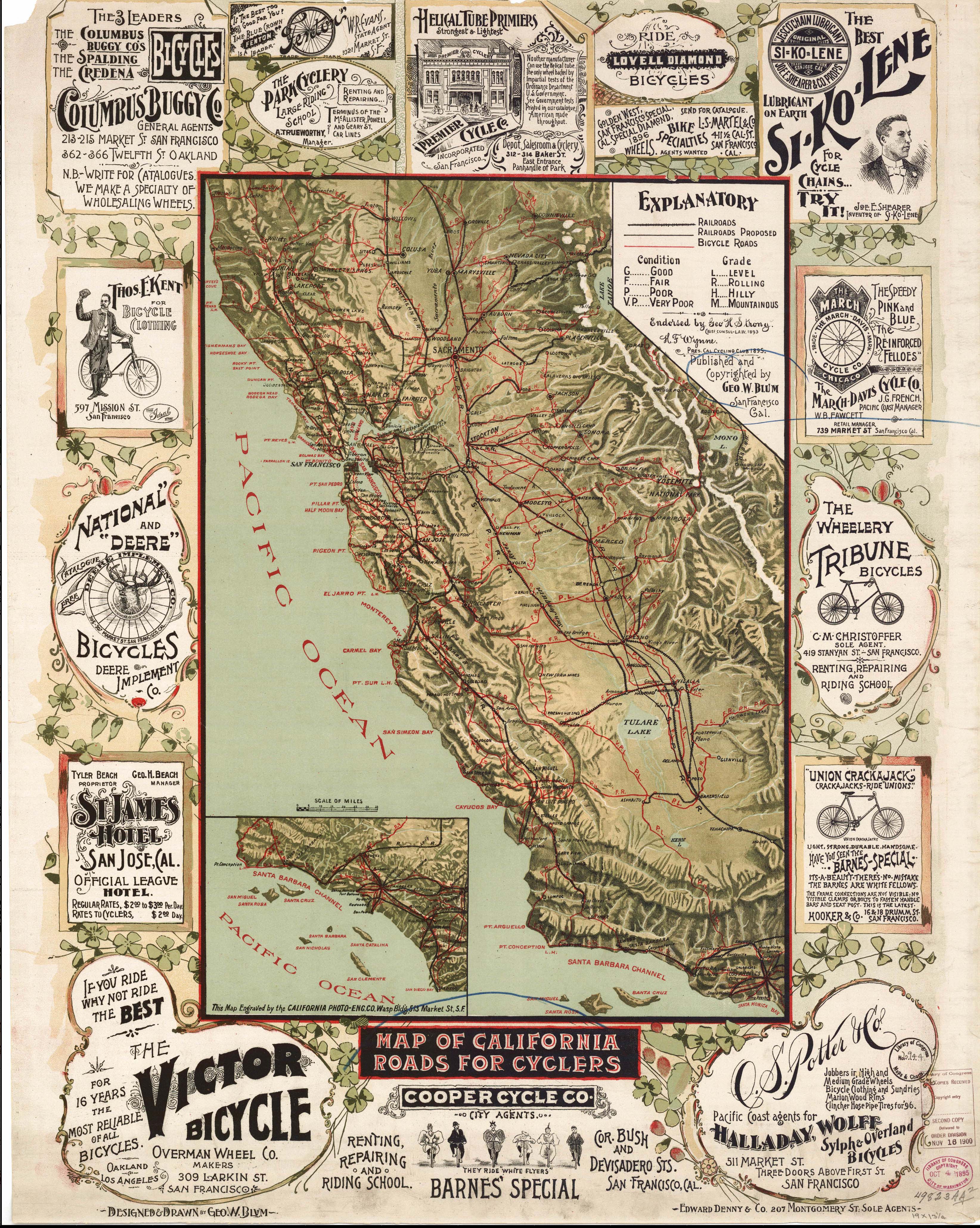
Here the researcher can find U.S. and state and county maps (which comprise the bulk of their collection). Here's a 1900 map of California roads for cyclers:


However what I find of particular interest is their collection of maps of Indian land cessions "during the interval between the formal establishment of the United States and 1894." Here's a map of California:

[Map 7, California from Indian Land Cessions in the United States, compiled by Charles C. Royce and presented as Part 2 of the Eighteenth Annual Report of the Bureau of American Ethnology to the Secretary of the Smithsonian Institution, 1896-97.  The Report was printed by the Government Printing Office in 1899]

They also provide links to the texts to the 375 Native American Treaties recognized by the Department of State.


© 2016 Copyright, Christine Manczuk, All Rights Reserved.

Monday, May 9, 2016

Fantastic Find: "Historical Maps Reveal Much More Than We Think"

This is Google Earth/David Rumsey layer map from 1733: "The first large scale map of North America and the most accurate at the time. It shows the extent of the British, French, and Spanish colonial possessions."  I might take a little tour tonight and see what this old lens on the world might show me about my ancestors back then.  Google Earth Pro offers a few of these layers, you can go to the David Rumsey site and find more maps to overlay on Google Earth.


Ancestry Blog had this nice tidbit today from Pamela Boyer Sayre and Rick Sayre about a few great sources they use for historical maps, and you know I love maps!


Edited to add: I am disappointed that the mapping function on the University of Virginia Census Browser that they recommended isn't working.  Is it just me?


© 2016 Copyright, Christine Manczuk, All Rights Reserved.

Saturday, January 23, 2016

A Background Look at How a Recent Atlas of Maine Was Made

Title Page of my copy of the atlas.
One of my favorite atlases is The Times Atlas of World History (Revised Edition), edited by historian Geoffrey Barraclough (New York Times obituary for him in 1985 here).  Over the years I've spent many years browsing through the pages, learning about migrations around the world and the various eras.

I use maps almost as much as I use records in my genealogy research.  Like records, it is good to know why and how these atlases are created.  They didn't just write themselves.  What does it take to compile such a work, and what are the decisions for inclusion and exclusion of information?

The following is a lecture that was given at the Schoodic Institute in Maine by scholar Richard W. Judd, who recently published "Historical Atlas of Maine" (available here and here) with Stephen Hornsby and Michael J. Hermann.  Although very much in the weeds, I found it fascinating to see a discussion of what lead up to the creation of the atlas, plus some sneak peeks into it (it's about $75, which is reasonable for a book like this).

BTW, I had to laugh when they got to 41:16 in the video when he shows "Village of Lock's Mills."  Look closely and you will see among the landowners someone named J.G. Tibbetts, a distant Tibbetts cousin of mine, no doubt.  Tibbetts seem to be all over Maine.


© 2016 Copyright, Christine Manczuk, All Rights Reserved.

Tuesday, December 8, 2015

Kingston, Linn County, Iowa: Comparing 1868/1869 and Now

Kingston was on the west side of the Cedar River opposite Cedar Rapids, as seen in this land ownership map.  D. W. Ensign & Co., "Map of Linn County, Iowa," Thompson & Everts (Geneva, Il.); digital image, Library of Congress: Maps (https://www.loc.gov/item/2012587552/ : accessed 8 Dec 2015).

Both of my parents had direct ancestors (Porter Worden/Hannah Leonard and George W Hartley/Rebecca Paul) living in Kingston City, Linn, Iowa in the 1860 Federal Census.  I have no idea if they knew each other.

Porter Worden (Ancestry's original indexer put Wooden) and family in "Rapids," yet their post office was Kingston.  Am I to assume they were west of the river, maybe in the rural area immediately outside Kingston?

George Hartley and family appear to be in Kingston proper.

Kingston does not come up as a place on modern maps.  It's existence is referenced by a modern apartment development at the terminal end of the old Kingston area limit:

Google Maps snapshot of the Kingston area.


I am not sure where exactly my ancestors lived in Kingston, but the northern part of it can be seen in this 1868 birds-eye view of Cedar Rapids:

These birds-eye maps are always fun.  A Ruger, "Birds eye view of the city of Cedar Rapids and Kingston, Linn Co., Iowa 1868." Chicago Lithographing Co.; digital image, Library of Congress: Maps (http://www.loc.gov/item/73693391/ : accessed 8 Dec 2015).

A closeup shows remarkably little in the layout of the area has changed compared to a snapshot from Google Earth today:


© 2015 Copyright, Christine Manczuk, All Rights Reserved.

Thursday, December 3, 2015

Where Were My Ancestors About 1796? Abraham Bradley's Map of the United States: Part 2

This is a continuation of my post earlier this week using Abraham Bradley's postal map of 1796.  This is just an exercise to get a handle on where all of my American ancestors were during the Federalist Era.  I can already see the fatal flaw of adding ancestors by going up and down my tree as opposed to grouping by location--for instance, I actually have a lot of people who were in the western Pennsylvania area, but there will be separate maps for the family groups in this iteration because they are on different branches of my tree.  I will put together a more concise version at a later date.


In Bertie County, North Carolina, possibly in the Salmon Creek area, John H Hardy, 23, was married to his first wife, Jamima Wilson, and they had a toddler Etheldred.  Jamima would die in the next year.  John's mother Sarah Sowell, 63, had been widowed 3 years before when her husband William Hardy died, and she would be listed in the 1800 Federal Census as head of household in Bertie County, North Carolina.   John's future second wife, Elizabeth Ward, 21, daughter of Thomas Ward (who had died the year before at about age 60) and Pheraby Sowell, about 47.  John Hardy and Elizabeth Ward were distant cousins--their mothers were both descendants of Richard Sowell (born c. 1659).


John Chappell, 33, had moved to Georgia probably in the mid to late 1780's from Sussex County, Virginia, likely with his parents, Revolutionary veteran John C Chappell, 58, and Nancy "Nannie" Harrison, 55.  Like Jesse Warren Sr he was in the area that would become Hancock County, Georgia. John and his wife, Sarah "Sallie" P Heath, 25, had several small children by the time the map was made.  Sallie was the daughter of Valley Forge veteran Abraham Heath, 56, and Winnifred "Winny" (??), 50, who had moved from Surry County, Virginia to Burke/Warren County, Georgia 10 years earlier.
Josiah Freeman, 33, was likely in Oglethorpe County, Georgia with his first wife, Susannah Hawkins, and at least 5 small children.  He had likely moved to Georgia sometime between 1786 and 1790.  He was originally from Virginia, possibly Sussex or Surry counties.  His parents William Freeman, 58, and Sarah Williams(??), about 56, were in Surry County, North Carolina, and may have originally been from Surry County, Virginia.  All these Surry counties!!  It gets confusing.  Elizabeth Jordan, Josiah's second wife, was only about 9 in 1796.  I have not yet figured out who Elizabeth's parents were.  Elizabeth was born in either Georgia or possibly South Carolina.
Richard Turner, 17, had been born in Cascade, Pittsylvania, Virginia, and had moved with his family to Wilkes County, Georgia (part of which became Lincoln County) when he was about 5.  His parents, Shadrack Turner and Margaret Hill, were both about 45.  Mary Henderson, 15, would marry Richard about 3 years later in Wilkes or Lincoln County.  She had Virginia as place of birth on the 1850 and 1860 Censuses, but I have not yet been able to determine who her parents were, although there were numerous Henderson families in Elbert County (neighbor county to both Wilkes and Lincoln) at the time she would have married Richard.


William Porter was born in May 1796 in Sheffield, Caledonia, Vermont, to Benjamin Porter, 24, and Lydia Wilcox, 21.  It is not clear why they were there, as they had married in Surry, Cheshire, New Hampshire the year before, and were back there by the 1800 federal census.  Benjamin's widowed mother Esther Carpenter, 57, allegedly didn't die until 1827 in Lyme, Grafton, NH, but apparently didn't head a household in the censuses and probably lived with one of her adult children.  Lydia's parents, physician Obediah Willcox, 72, and Sarah Talcott, 61, were likely living in Surry, Cheshire, New Hampshire.
Joshua Shepard, 43, and Lucia "Lucy" Farnsworth, 34, were living in Alstead, Cheshire, New Hampshire.  Joshua's parents, Jonathan Shepard, 87, and Love Palmer, 79, had divorced 32 years earlier (about 1764), and had both subsequently remarried.  Love had married a Mr. Heard or Herrick (date unknown), and she died 23 July 1796 in Alstead, Cheshire, New Hampshire.  Jonathan had married Mary Underwood in 1765 and lived in Windsor, Windsor, Vermont, where he died 2 years after this map was made (26 March 1798).  Lucy's parents, Thomas Farnsworth, 65, and Elizabeth Davis, 68, also lived in Alstead (they had moved there sometime between 1776 and 1790).


© 2015 Copyright, Christine Manczuk, All Rights Reserved.